


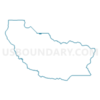
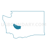
Voting District 31-601, Pierce County, Washington
About
Outline

Summary
| Unique Area Identifier | 688066 |
| Name | Voting District 31-601 |
| County | Pierce County |
| State | Washington |
| Area (square miles) | 0.78 |
| Land Area (square miles) | 0.78 |
| Water Area (square miles) | 0.00 |
| % of Land Area | 100.00 |
| % of Water Area | 0.00 |
| Latitude of the Internal Point | 47.25366510 |
| Longtitude of the Internal Point | -122.27749230 |
Maps

Graphs
Select a template below for downloading or customizing gragh for Voting District 31-601, Pierce County, Washington


Neighbors
Neighoring Voting District (by Name) Neighboring Voting District on the Map
- Voting District 25-123, Pierce County, WA
- Voting District 25-124, Pierce County, WA
- Voting District 31-602, Pierce County, WA
- Voting District 31-604, Pierce County, WA
- Voting District 31-608, Pierce County, WA
- Caddis Voting District, King County, WA
- MIL 30-3146 Voting District, King County, WA
- PAC 30-0887 Voting District, King County, WA
- Trout Lake Voting District, King County, WA
Top 10 Neighboring County Subdivision (by Population) Neighboring County Subdivision on the Map
- Tacoma CCD, Pierce County, WA (427,051)
- Federal Way-Auburn CCD, King County, WA (165,504)
- Puyallup CCD, Pierce County, WA (152,823)
Top 10 Neighboring Place (by Population) Neighboring Place on the Map
- Lakeland South CDP, WA (11,574)
- Edgewood city, WA (9,387)
- Milton city, WA (6,968)
- Pacific city, WA (6,606)
Top 10 Neighboring Unified School District (by Population) Neighboring Unified School District on the Map
- Puyallup School District, WA (118,946)
- Auburn School District, WA (84,053)
- Sumner School District, WA (43,512)
- Fife Public Schools, WA (20,462)
Top 10 Neighboring State Legislative District Lower Chamber (by Population) Neighboring State Legislative District Lower Chamber on the Map
- State House District 25, WA (145,035)
- State House District 31, WA (137,685)
- State House District 30, WA (129,998)
Top 10 Neighboring State Legislative District Upper Chamber (by Population) Neighboring State Legislative District Upper Chamber on the Map
- State Senate District 25, WA (145,035)
- State Senate District 31, WA (137,685)
- State Senate District 30, WA (129,998)
Top 10 Neighboring 111th Congressional District (by Population) Neighboring 111th Congressional District on the Map
Top 10 Neighboring Census Tract (by Population) Neighboring Census Tract on the Map
- Census Tract 735, Pierce County, WA (7,030)
- Census Tract 707.03, Pierce County, WA (6,065)
- Census Tract 309.02, King County, WA (5,605)
- Census Tract 733.01, Pierce County, WA (5,467)
- Census Tract 304.03, King County, WA (4,270)
- Census Tract 304.04, King County, WA (4,208)